|
This walk can be done from the campsite at Cwmdu,but this will extend it by
2 miles,alternatively if you park (or get dropped off) two miles away from the campsite, on the A479
(direction of Talgarth) by the telephone box its approx 10miles
Distance Approx 10miles
Mostly flat 1 short steep climb to the fort
Terrain Qiuet country roads and paths,which can be very muddy in places
Map OL13
Highlights Iron age Hillfort great views
| Click to enlarge |
|
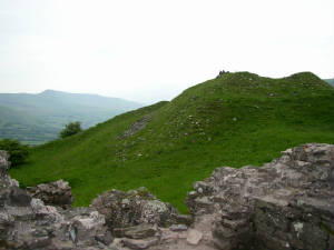
| Castell Dinas |
Assuming you have parked at the telephone box walk back down the road to the side turning on the left,
follow this.After a short distance a bridleway is sign posted on the left,ignore this,there is
however a public right of way just past this on the left opposite a building.This is not waymarked and
can be difficult to find,so the alternative is to continue along the road until you reach a cross roads,
go left and follow to the end where the road gives way to a track continue along this.
This path/track can be very muddy in places as horses and four wheel drives have carved it up,
as you continue you will cross a number of fords and also follow the small river,
you then reach a road,walk a few yards downwards and then on your right the path continues
follow this for about 3/4 mile and after passing a few building on the right look out for a stile on the right,
go over this and you are on the permissive footpath to the fort,across the field over the stile and start
to climb the hill,over another stile and keeping the fence to your left, up to another
stile,climb this and bear right to the top of the hill, you have now reached Castell Dinas
Bear left to the top of the mound this is a great place for lunch.
The Iron Age dates are 750 BC to AD43 so this area would certainly have been
occupied during this period.Britain was really just covered by farms and small
villages with no towns and a estimated population of 1-2 million people
The main development of the actual castle dates from early Norman times late,12th or early
13th century and reputed to have been destroyed during a rebillion by a chap called
Owain Glyndwr a century or so later.
A slight detour will take you to The Castle Inn,I have not had
a chance to sample
a pint here but by all accounts its serves a decent real ale and good food.
Leave the hillfort through the remains of the northern gateway and then going down the hill to the bottom
through the gate/stile on the left meeting a small road that leads to the A479 at Pengenfford
Cross the road go down the lane dead ahead to the farm,follow the signs the farmer has put up
going right then left and the track goes upwards The track levels out and contours around Mynydd Troed,
follow this until the road,go left for a few yards and then a path continues on the right,follow this as
it goes gently downhill until it meets a gate,go through this onto a better path.
(if you have parked at the phone box a road goes down to the the left
follow this to your car)
The path continues along to another road ,which takes you back to Cwmdu past the church and
pub and back to the camp site if you are staying there
ENJOY THE WALK
Home
|